click hide image

Showing posts with label geology. Show all posts

Tuesday, April 17, 2018

Your Soundings Green Ooze

When ornithologists plumbed the depths of the seas


There is nothing very Remarkable between these places, saving the high ridge of land that comes from the Quoining Land, seen on the back of Mangalore, that receives Basallore hill, and trenches northward far into the Country; the Coast is bold all the Way, and your Soundings green Ooze. Pidgeon Island is six Leagues off the Main, and may be seen as far Northward or Southward; the Channel made between is unquestionably good. There is a small naked rock adjoining to this island, where multitudes of Pidgeons breed; I have taken a great many fine Oysters from thence at low Water, but you must carry Scrapers and long spikes to strike them off. The Latitude of Pidgeon Island is in fourteen Degrees five minutes North.
On the French national library, there is a fragment of a book The port and prospect in and near the river of Mangalore ; A prospect of the Mulkey rocks ; A prospect of Pidgeon Island published somewhere in the 1700s it is part of a collection belonging to the cartographer d'Anville. Pigeon Island is what is today called Nethrani Island, known to be one of the best and most bio-diverse coral reefs close to mainland India and one that has hardly been carefully examined - mainly because the island is used for target practice by the Indian Navy who bomb it periodically with torpedoes. It is also said to have the world's highest density of nesting White-bellied Sea-eagles. 

Sounding Leads
What caught my attention was the information given to navigators - "your Soundings green Ooze." Trying to make sense of this phrase led to an examination of navigation practices in the period. Sounding is a word for finding the depth of the sea-floor and it comes from ancient times, well before sounding actually was done using sound - with sonar, reflecting sounds off the sea floor and calculating the distance based on the time taken for echoes. 

Sounding in the old days were done using "sounding leads" - special blocks made of lead or other heavy metals (incidentally the plumb in plumb line - comes from plumbum, Latin for lead). The block was lowered down the side of the ship and had a cavity at the bottom that could be lined with tallow, bees-wax, soap or other sticky material or a small saucer at the end that collected a sample of the sea floor. The sample that came up would tell something about the nature of the sea floor, it could be sandy, rocky or, it could come up with foraminifera ooze - and in which case it would go into the log books as sticky green ooze. Navigation on rivers was perhaps a bit easier and made use of a sounding pole with graduations. They too had a cup at the end that allowed sampling of the floor. (The call of "Mark Twain" was made by Mississippi river pilots who found the water depth to be two fathoms.)

Nautical charts routinely indicate seabed types and this tradition was mainly to examine spots for anchorage and not so much for scientific analysis although they were used as indicators for good fishing and for identifying the nature of currents based on the distribution of silt deposits at the mouths of rivers. With the establishment of marine surveys, a more systematic sampling of sediments was undertaken with a view to find larger scale patterns. Drilled cores of the sea bed in the Arabian Sea allow for examination of the deposition of the ooze over time. One of the patterns is that the ooze deposit is correlated with the Southwest Monsoon. It may be related to the flow of nutrients with rainwater runoff and the resultant growth. The data from these cores have been used as proxies to understand long-term patterns in the monsoon and its strength. For an example of the modern techniques available and what they can reveal - see Schmiedl, G., and D. C. Leuschner (2005). But let's get back to an earlier age.

A history of the Indian marine surveys has been written by Clements Markham (but it is worth remembering that he can be unreliable at times - as in his Cinchona history). The first surveys by the navy of the East India Company focused on ports and navigation.  The trend was continued until the ending of the "Indian Navy" (not to be confused with the post-Independence organization) in 1862. In 1873, a Marine Survey Department was established. The Department was headed by Commander A Dundas Taylor and included Staff Commander J.H. Ellis, RN as deputy superintendent. It also included Dr J. Armstrong as surgeon and naturalist. The marine surveys included as part of their study, the mapping of depths, and the examination of marine organisms as well.

One of the early survey assignments for Commander Ellis was aboard the Clyde. In the General Report of the Operations of the Marine Survey of India from the Commencement in 1874, to the end of the official year 1875-76 by Dundas Taylor we read on page 7 that they had an unlikely passenger on board in 1875.
The whole thing about measuring a meridian distance between Pigeon Island and the Laccadives (Lakshadweep) and remaining there for a fortnight seems like a clever ploy initiated by Hume, the Secretary to the Government of India, to hijack the government machinery for his ornithology.

Hume's own note published in his Stray Feathers is a good read:

Reading through Hume, it is clear that he has all the background needed to do his job of identifying locations for lighthouses. He knows for instance the location of the wrecking of the Chaldea in the previous year. He takes an unusual interest in the plant life on the islands during this trip. Strangely he does not mention much about the bird-life of Pigeon Island. He notes the numbers of sea-eagles nesting on the Vengurla rocks that they encounter earlier off Goa. Hume writes:
One object that I had in view in making this trip was to ascertain whether or not the Laccadives were separated by a deep trough from India—a matter which up to this time had remained uncertain.

I had, therefore, indented on the Bombay dockyard for deep sea line, and they supplied some five or six thousand fathoms of splendid looking line. Our Captain, an old Porcupine man, entered most cordially unto my views, and soon after we left Bombay, took the line in hand and began testing and marking it. To our dismay it soon appeared that the line was in many places rotten. Whilst we lay at Pigeon Island, the Captain had a lot of it carefully picked over, all bad pieces picked out and   the  good  carefully  spliced  together.
One really wonders why a marine survey vessel did not have the necessary equipment for sounding already on board. ["Porcupine man" apparently refers to the fact that Ellis worked on the HMSS Porcupine - see this which puts him aboard the Porcupine around 1873 and has nothing to do with the skin disease]
Wallace's 1863 map

Hume's copy of Darwin's Origin of Species
(first edition).
Courtesy: SLBI

Anyway, what this does make clear is that Hume would have read the work of Alfred Russel Wallace. Wallace's 1863 paper was communicated to the Royal Geographical Society by Clements Markham and Markham would have been closely associated with Hume during the course of the cinchona work under the aegis of his Department of Revenue, Agriculture and Commerce. Huxley had named it the "Wallace Line" in 1868. Wallace shared some of Hume's interests in the occult and Theosophy. (Hume had of course read Darwin and Hume's copy of a first edition of The Origin of Species is at the South London Botanical Institute) Hume was also in touch with the geologists of the Geological Survey of India from the time of Stoliczka. Richard Lydekker had joined the GSI in 1874 and in 1879 Hume got him to write about the skeletal structures of birds based on his training in paleontology. Interestingly Lydekker found another now eponymous biogeographic delineation of Australia in 1895. At the end of the Laccadives trip report, Hume includes three bathymetric charts in this issue of Stray Feathers - of the Laccadives, Cherbaniani Reef and Kiltan Island. It is rather interesting considering that printing illustrations was so much of a problem in those times. He also spends considerable space in exploring the origin and geological structure of Betra-par - whether it has a rocky core or if it is entirely formed out of coral reefs. He had samples of the soil tested by the GSI. He collected molluscs that were identified by Nevill of the Indian Museum. Plant specimens were also collected and these were examined by David Prain.
Hume's Laccadive soundings published in Stray Feathers

The engine on the Clyde broke down on February 21 and attempts were made to get it to sail but tacking was not possible as it lacked a keel. With great difficulty they reached Thoothukudi where Hume exited to make his way to Madras but with some travels on the way. Incidentally, the Gunboat Clyde was manufactured by the famous Wadia family (which produced the geologist D N Wadia). The builder was Rustomjee Ardaseer, son of Ardaseer Cursetjee, the first Indian Fellow of the Royal Society. Commander Ellis' report includes the rest of the saga. (The Clyde 1857 was a 300 ton steam gunboat capable of carrying 18 guns and had a 60 HP engine - see )


Hume writes:
At last we made Tuticorin, and I had had enough of the old "Clyde," to which I here bade farewell, devoting the rest of my leave to Southern India, the Pulneys, and Neilgherries, of which I need say nothing here.
I fancy that he would have visited his good collaborators S.B. Fairbank in the Palnis, Margaret Cockburn in Kotagiri, his collector W R Davison in Ootacamund, and his cousin Edward Balfour (who left India in 1876) in Madras before taking the train back towards Calcutta or Shimla.

We tend to think of most of the colonial ornithologists as mere collectors, making use of their presence in a particular location to supply others with specimens, but these and other examples from Hume's work clearly indicate that he had underlying theories and sought to find evidence either in support or against them. This is especially useful as a lesson for beginner birdwatchers - Max Nicholson wrote in his Art of Birdwatching - "One cannot observe without a theory, and what seems the simplest of ornithological tasks - to go out of doors and look out for something worth recording- is in reality one of the hardest ... It is a mistake to imagine that complete impartiality and freedom from preconceived ideas is the qualification for the perfect observer. The cow has a remarkably open mind, yet it has never been found to reach a high degree of civilization." Ernst Mayr is supposed to have expressed a similar idea which Joseph Hickey recalled as "everybody's got to have a problem." Mayr expected even ordinary bird enthusiasts to have big biological questions at the backs of their mind so that they might make more critical observations.

The idea of soundings and sea depth measurement to examine continental boundaries and thereby bio-geographical boundaries did not stop with Hume. He seems to have influenced his collector W R Davison as well. When Davison went on to take up a position at the Raffles Museum in Singapore (the Straits Settlement in those times), he decided on delineating his area of specimen collecting, which included numerous islands, using a cutoff at a distance where the sea floor depth exceeded 50 fathoms (Professor Kevin Tan of Singapore in his history of the Singapore museum has many biographical details on Davison including his tragic death - see Tan, 2015).

Postscript - a Bangalore connection

(Actually posted as a message on the list - bngbirds on 30 Sept 2013) Hickey mentioned above was himself inspired by Nicholson and wrote a book called the Guide to Bird Watching as part  of his Master's degree! This book inspired a Mrs M.D. Wright, wife of a forest officer in India at Dehra Dun. She counted birds and wrote a remarkable piece in the Journal of the BNHS in 1949. She also influenced Dr Joseph George who conducted studies on drongo numbers and published many notes in the Indian Forester. Dr George went on to establish a lively group of bird-watchers in Bangalore.

Interestingly, Salim Ali seems to have glorified the idea of the "unbiased observer". The debate around having paradigms or frameworks for observation has obviously taken place before and I would subscribe to the view of Goodin (2006) that allowing for a multiplicity of biases is more helpful that claiming to be unbiased, which really is a state that is unachievable. A truly unbiased person would be taking a random walk, never reaching any specific destination!


  • George, J. (1957). Birds of New Forest. Indian Forester, 83(11):674-687.
  • George, J. (1957). Birds of New forest. Indian Forester, 83(12):724-737.
  • George, J. (1962). Birds of New Forest: 1957-1962. Indian Forester, 88(6):442-444
  • George, J. (1958). Bamboo Nestboxes. Indian Forester, 84(11):687-692.
  • George, J. (1958). A Young Dark Grey Cuckoo-shrike. Indian Forester, 84(5):286-287.
  • George, J. (1960). Tolerance of Birds to Ascu - and Creosote - Treated Nesting Sites. Indian Forester, 86(12):753-754.
  • George, J. (1961). Bird Counting. Indian Forester, 87(9):572-575. [reprinted in 1961 NLBW 2(12)]
  • Goodin, Robert E. (2006) The Epistemic Benefits of Multiple Biased Observers. Episteme 3(3):166-174.
  • Wright, M.D. (1949) A bird count in Dehra Dun. J. Bombay Nat. Hist. Soc. 48(3):570-571.
Postscript 12 August 2020: In Hume's notes on the birds of Manipur (1888) he discusses his understanding of evolution. He clearly seems to know about competition, niches, and the process of speciation and appears limited only due to his use of morphology for comparing evolutionary closeness.

Hume puzzles over Garrulax moniliger and G. pectoralis which he thinks are closely related:
...differing only in size, ... are almost always found in the same localities..

There are many other pairs differing similarly only in size, but then they belong to different localities, and where their distribution areas interlace or overlap we do get intermediate forms.
How is the existence of these two forms to be explained on our modern principles of evolution? They breed in the same localities at the same time. They are not like some of the small waders said to have a smaller and larger form, some bred in temperate and some in high arctic regions.
They must have had a common ancestor; their food is the same (I have compared the contents of the stomachs of three of each ...

To me this is a mystery, and indicates that our present evolution hypothesis itself requires further evolution.

Further reading

Postscript 

1-June-2022 - Hume seems to have had some reservations about Darwin's theory of evolution - the word "evolution" occurs about three times in the context of species in the volumes of Stray Feathers. He clearly does accept an ancient earth and species colonization - in fact he considers several biogeographical questions. See for example. And after his Manipur expedition he talks about the possibility of two species of different sizes with identical food habits occupying a common niche (my words) - "...is a mystery, and indicates that our present evolution hypothesis itself requires further evolution." (S.F. 11: p.161-161)
Compare also some of the recent works on "plumage mimicry" - Leighton, G. M., Lees, A. C., & Miller, E. T. (2018). The hairy–downy game revisited: an empirical test of the interspecific social dominance mimicry hypothesis. Animal Behaviour, 137, 141–148. doi:10.1016/j.anbehav.2018.01.012

Thursday, September 22, 2016

Crowdsourced Indian geology in the 1800s

Crowd might be a bit of a stretch for less than a hundred contributors but George Bellas Greenough (1778 – 1855), one of the founders of the Geological Society of London produced the first geological map of India which was posthumously published in 1855. Greenough was the first president of the Geological Society of London and was reportedly best known for his ability to compile and synthesize the works of others and his annual addresses to the Society were apparently much appreciated. He was however entirely against the idea that fossils could be used to differentiate strata and in that he failed to admire William "Strata" Smith who produced the first geological map of England. One obituarist noted that Greenough was an outspoken critic of theoretical frameworks and a "drag" on the progress of the science of geology!

Not much has been written about the history of the making of the Greenough map of Indian geology - it was begun somewhere in 1853 and was finally published in 1855, consisted of four sheets and measured 7 by 5¾ foot. A small number of copies were made which are apparently collectors items but hardly any are available online for anyone wishing to study the contents. The University of Minnesota has a set of scanned copies of three-fourths of the map but if you want to read it you need to download three large files (each of about 300 MB!) . I decided to stitch together these images and to enhance them a bit and since the image is legally in the public domain (ie. copyright expired), I have placed it on Wikimedia Commons. There really is a research need for examining the motivations for making this map and on how Greenough went about to produce it. He apparently had officers of the East India Company providing him information and he seems to have sent draft maps on which they commented. There is a very interesting compilation of the correspondence that went into the making of this map. It has numerous errors both in geology as well as in the positions and labelling but is definitely something to admire for its period. Thomas Oldham representing the professional GSI in India was particularly critical while heading a committee (that included Henry "Cyclone" Piddington) to examine the map.

One has to lament that nobody has made a more up-to-data geological guide to interesting formations, fossil localities and so on.

Here is a small overview of the 1855 map. You can find and download the whole image on Wikimedia Commons.


You can zoom into this image and enjoy the details by using this viewer that uses the Flash plugin or this one that is Flash-free.
An even higher resolution stitch can be found here (with the zoom-viewer here)


PS: November 8, 2016 - just created an entry in Wikipedia for Henry Wesley Voysey (with the only known portrait of the man when no likeness has been recorded by the Oxford Dictionary of National Biography!) who is wrongly claimed by D T Moore to have made the first geology map of India - covering a part of the Hyderabad region (1821) but the two known copies of that map disappeared from Calcutta and London. An older geology map is by Benjamin Heyne published in 1814.

😃April 11, 2018 - thanks to David G. Bate, there is now a complete map in the French digital library. The above image is now complete.
 

PS 6-May-2022: Some years ago I had collected examples of crowd-sourcing in science from India, and had misplaced them. So here is another example where the Asiatic Society of Bengal was trying to study barometric pressure trends across the country by distributing "philosophical instruments" to collaborators across India. From Journal of the Asiatic Society of Bengal. Volume 5. 1836.

Friday, July 29, 2016

Isostasy and Apostasy

What?! Those two words appear to have little to do with each other,  but they were at the heart of some conflict, the conflict between geology and religion in Europe. For outsiders in places like India, this conflict is hard to understand and is not a significant part of the public understanding of science.

I came to read up about isostasy, thrown off on a tangent from a research trajectory that began with something linked to Bangalore. That research ramble included forays into the life of William Lambton, who began experiments on the Great Trigonometrical Survey at Bangalore, the discovery of strange errors in surveying and Himalayan geology. Along the way I also noticed characters of interest from a recent trip to Italy. I realized that we know so little of the evolution of science and the history of tussles between religion and science. This seemed especially to be a gap for those of us living in the non-Christian world where science and fiction meld into each other.

Archdeacon Pratt (1809-1871)


Our story begins with the Earth. Several early scientists reasoned that the Earth must have been a piece of irregular material which was either hot and liquid or made up of bits that broke off from a bigger solid and behaved like a fluid over time to rearrange itself into a nearly spherical form. One early scientist in particular did the mathematics of it and figured out how much it would bulge at the equator on account of its rotation about an axis. Understanding the shape of the earth was an important part of navigation and that also translated to questions of Empire and supremacy. The man we are interested in, who wrote a treatise on the physics and geometry of the earth, was a brilliant mathematician, a Cambridge Wrangler (number 3 for 1833), who decided to take up a job as a clergyman in India just to have the free time and peace of mind to pursue mathematics. He was so good at his work that he was nearly appointed a Bishop. After the orders were passed, they were rescinded in the light of the 1857 revolt and the powers that be instead chose George Cotton to become Bishop Cotton, after whom many schools in India are named. Alumni of that school would probably have been far prouder if their school had instead been named after the Archdeacon of Calcutta, John Henry Pratt.
Pratt was such a brilliant applied mathematician that he was would regularly be sought to solve problems faced by engineers and officials in the government. He would evaluate the strength of metal bridges, arches and trusses. As a member of the Asiatic Society of Bengal, he attempted to put a date on ancient Indian writings on the basis of star positions. Pratt's biggest area of research was however on the shape and structure of the Earth. Early on, Archdeacon Pratt saw mountains as a problem! The problem really was that they shouldn't exist if one assumed the fluidity of the Earth. Assuming the fluid nature of the earth and the time available for the earth to become nearly spherical, the irregularities on the surface should be far smaller. Isostasy deals with the forces that resolve that problem.  Pratt was brought to think about mountains more deeply when Surveyor General Andrew Scott Waugh  (who succeeded George Everest) came to him with data that showed an odd pattern on errors in the estimation of the heights of peaks in the Himalayas. The peaks appeared to be higher when measured from far away and when measured from closer up they seemed to lose some of that height. The source of the problem was already known as the errors were lower when star references were used but the errors became great if theodolites were used in computing angles. Theodolites use plumblines to define the vertical and it was known that plumblines lean towards mountains due to their gravitational attraction. So the angle from downward vertical defined by the plumbline to the top of the peak of a mountain is less that what you would measure if the plumbline actually pointed to the true centre of the earth.

Now Pratt looked at the data more carefully and did some calculations and found that this plumbline attraction was not as great as it ought to have been. His estimate was based on volume and density for the Himalayas. Since it did not match up he decided that the density of the Himalayas that he used must be incorrect. He then suggested the idea that below the mountains, the material was much denser and that the mountains rose like fermenting dough, fluffy and of lower density and resting on a denser base. That is isostasy (and there is a standard model in geology named after him) but Pratt was a clergyman and his other big problem was that anyone looking at geology could not fail to find fault in Christian religious teaching. Pratt was deeply disturbed and he wrote a book called Scripture and Science not at Variance in 1856 and it went through several editions. That religion and science conflicted long before Darwin is often forgotten today. Before Darwin, the central issue was the age of the earth. Calculations were attempted by many and they all differed from scriptural views by several orders of magnitude. Part of the problem in this really was that the ones who made these estimates were not "scientists" in the modern sense of the world - many of them were in fact clergymen! These were the same clergymen who had taken to natural theology / natural history in the tradition of John Ray's advice to contemplate on the Works of Creation on Sundays. The trouble was that all this contemplation led to the growth of geological knowledge which left the clergymen-scientists deeply conflicted. 
Fossils seen on a walk on an Italian mountainside.

When early Europeans saw mollusc fossils on the tops of mountains, they were quick to use it as evidence of Biblical floods. When I saw a few fossil molluscs, in the wild so to speak, on top of a mountain near Lake Como, I was filled with ecstasy. I put myself back in time by a couple of centuries to imagine what I might have made of it. Two centuries ago there were so many ideas floating around - there were competing theories of earth origins. Some saw from the evidence of volcanoes and igneous rocks that the earth may have been hot to start with - the plutonists - while others favoured the idea that igneous rocks were born under water - the neptunists. I suppose neptunism was more in line with scriptural ideas. Before this there were other geological debates including that between Catastrophism vs Uniformitarianism. It is easy to see how evidence and interpretation played such a big role in the development of science. I had read and researched about at least a couple of Italian clergyman-geologists (or naturalists) who had lived in the same district that I visited. Northern Italy produced Antonio Stoppani  (a force behind the natural history museum at Milan) and Ermenegildo Pini - subscribers of the Concordismo, an Italian movement to resolve the conflict between geology and religion. This Italian school tried to settle the matter by suggesting that the scriptures were not to be read so literally. Stoppani encouraged the study of geology by everyone. He wrote a popular book called Il Bel Paese (the beautiful country) that demonstrated how a knowledge of geology enhanced one's appreciation of the country. It was a best-seller and went into numerous editions and was a standard fixture in schools for a long time. A famous cheese manufacturer named his brand of cheese Il Bel Paese and that brand is now far better known!

The Grigne mountains. At the centre of this scene an
arch of land can be seen. This was carved by water during
the Ice Age.
Some Italian cheese inspired by geology!

People who could see geological evidence had the option of keeping their ideas to themselves. Wealthy people were probably more capable of expressing ideas freely as they had less to fear. Darwin had seen the case of the Devil's Chaplain in his youth and lived in fear of upsetting religious powers. It was the support of people like  Charles Lyell that let him publish. I have wondered often if the amateur-scientific establishment in colonial India, distanced from such social tensions lived with less fear. I have not seen an analysis of  such tensions or the lack of it in the  contents of the journals of learned societies in India.

I know however of one ornithologist who was influenced by the development of secular ideas - A.O. Hume. Hume learned a bit of geology under Gideon Mantell, a friend of Charles Lyell. He came from a family with a radical political affiliation and clearly did not subscribe to many ideas of Christianity. He sought spirituality, something free of the politics of religion, in the Theosophical movement founded by Madame Blavatsky. Sadly he found that organization too corrupted for his taste. At one point he sought to have Madame Blavatsky and others removed from the Theosophical Society for trickery and dishonesty! He earned the ire of the other members when he tried to define the aim of the Theosophical movement in a book. A person signing "K.H." (the Koot Humi a pseudonym possibly of Blavatsky herself) wrote: "I dread the appearance in print of our philosophy as expounded by Mr. H. I read his three essays or chapters on God (?)cosmogony and glimpses of the origin of things in general, and had to cross out nearly all. He makes of us ''Agnostics''!! ''We'' do not believe in God because so far, ''we have no not have proof'', etc. This is preposterously ridiculous: if he publishes what I read, I will have H.P.B. or Djual Khool deny the whole thing; as I cannot permit our sacred philosophy to be so disfigured...."

Any readers residing in London may be interested in a talk on Hume and Theosophy on 19 September 2016.

I am hoping to visit Hume's home, Rothney Castle, at Shimla in early August 2016 and my next post will be on that topic.

Further reading

 Note:A bit of amusement for those who know me!
An Italian journalist had a brief conversation and
makes a mention of my tryst with Ermenegildo Pini!
Postscript: 24 July 2018 - visited the Sea Point contact zone at Cape Town, where Darwin pondered over Neptunism v. Plutonism.

Saturday, August 15, 2015

Hammers, chisels, birds and beards

Imagining the history of the earth is an old pursuit. From fascinating tales of floods and elaborate fantasies of rat-designed Norwegian coastlines, ideas on landform origins have been built up by piecing jig-saws of evidence from fragments of coastline, fossils, magnetometry, isotope markers and a growing range of tools. The early geologists had far fewer tools but that was probably made up for by a great deal more excitement. Imagine calculating the rates of deposition of sediment and calculating the age of cliffs to find that it did not meet Biblical teachings. Early geologists had to tread with caution, but it was probably much easier if you were far away in places like India. 

The profession of geology in India can be traced to the period when travelling from Europe to the colonies in India became faster with steamships. Steamships evolved from using auxiliary paddles to propellers and screws. Steamships required coal and it was not always easy to store enough for a journey or even to stash along the route. The geology of coal was essentially a study of old forests, paleontology, and the people involved in its quest in India saw the land through a scientific lens (and toolkit) that differed from that of the physician naturalist (and of course that of the parson naturalist). The geologists tended to have a much keener sense of spatial patterns, associations with climate, patterns of dispersal and how land barriers may have worked to separate populations and create species.

We have already seen how Professor Robert Jameson's geology classes, attended by the likes of T.C. Jerdon and Charles Darwin had an enormous influence on them despite Darwin's claim that "the sole effect they [Jameson’s lectures] produced on me was the determination never as long as I lived to read a book on Geology, or in any way to study the science"! It is unsurprising that geologists in this period were fairly well-rounded naturalists.

The Geological Survey of India (1870)
Hammers, chisels, birds and beards
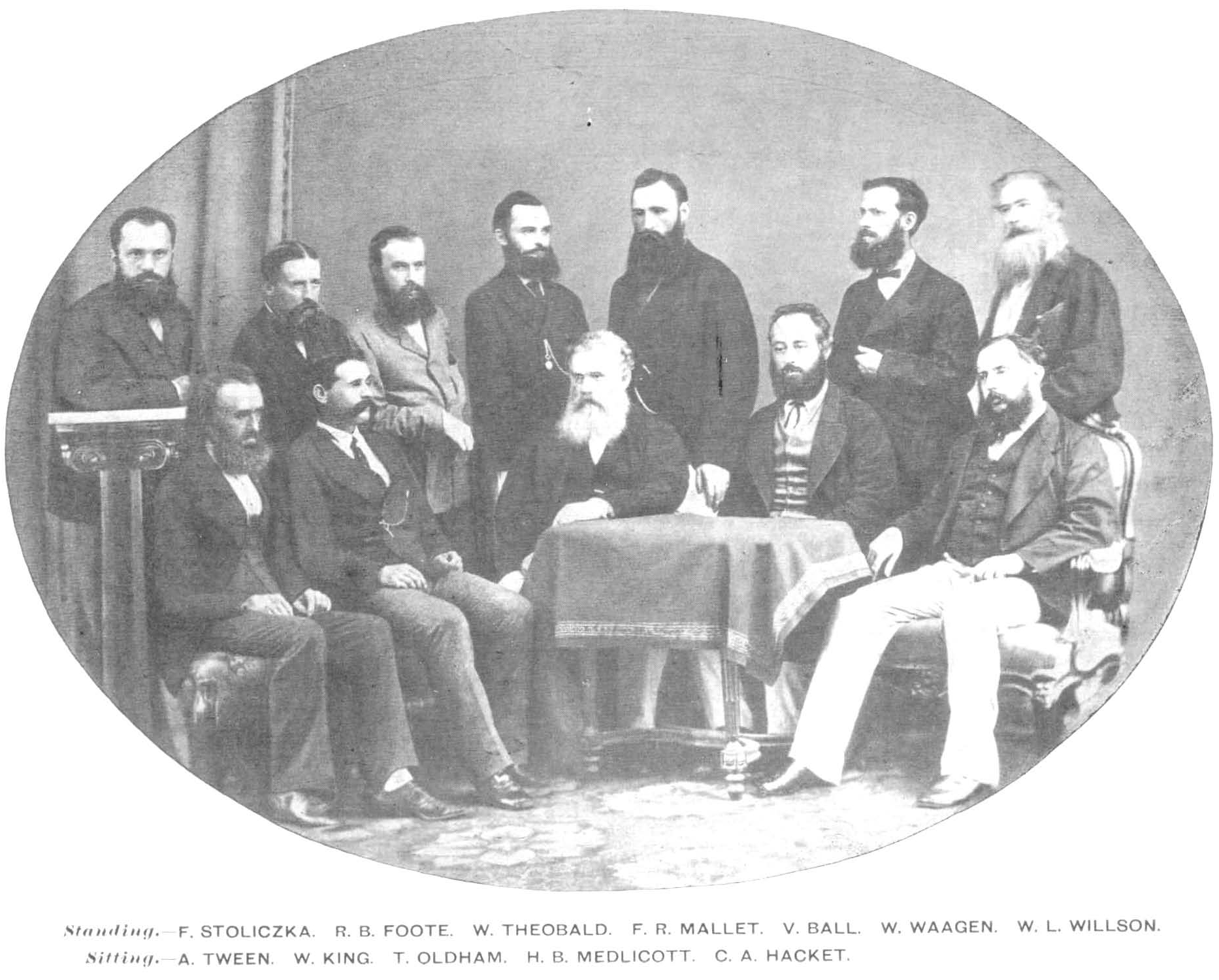
There is an interesting old picture of the members of the Geological Survey of India in 1870. All of them are bearded, several from Ireland, and a couple of Europeans (a Moravian and a German) influenced by studies in Austria. Of this bunch, the man at the extreme left - Ferdinand Stoliczka, would contribute greatly to ornithology before dying young of altitude sickness. Standing fourth and fifth from left are F.R. Mallet and Valentine Ball who were also keen ornithologists. Ball was also into ethnology and when the first railway lines were being laid, he would advice the government on the best paths in central India to connect the coal fields of the Chota Nagpur Plateau with the port of Bombay. Both Ball and Mallet were Hume collaborators. Ball even joined Hume on the Andaman expedition and his name lives on in Otus balli. We get some idea of their zeal for collection from the writings of another Czech/Austrian who came replace the paleontologist's post held by Stoliczka. Otokar Feistmantel notes how they would travel with a large retinue of servants, three elephants and lavish tented accomodation arrangements. He pointed out that he was free to use the gun as he liked - something that only the royalty could do back in Europe. Feistmantel's also notes how European life in Calcutta revolved around the beach(!) and should be interesting reading for Kolkatans today. The grand work on the Fauna of British India series was placed under the editorship of a geologist W. T. Blanford. His brother H. F. Blanford went on to set up the Indian Meteorological Department, the order for its establishment being signed by Hume himself (although Blanford gives more credit to Richard Strachey, one of Hume's "opponents" in the Agriculture Department)

More recent ornitho-geologists like Jürgen Haffer took to geology for the secure career and prospect of travel that it provided. He worked extensively on bird speciation in South America and wrote a biographical note on his mentor Ernst Mayr and several interesting bits on the history (and philosophical phylogenetics) of European ornithology.

And from there we get to even more modern geologists who do not even have to travel to propose very interesting hypotheses in ornithology. In a series of articles by a team of geologists the idea has been proposed that grain size and soil properties create a somewhat narrow window of opportunity for large hole nesters and that the mechanical properties needed to support such burrows without collapsing are met by a specific soil type:- loess. The authors examine the breeding distributions of birds with loess deposits and find a substantial overlap. This naturally makes everyone worry that confirmation bias involved but the idea is clearly a very testable hypotheses and probably needs a lot more reading than it is getting especially within the ornithological community.

With modern academic specialization, it seems that geology and ornithology are never packed into the same person nor are persons from the fields teaming up. So it comes as a nice surprise to see some bold and fresh thinking in a recent series on the distributions of large hole burrowing bee-eaters. Looking at the citations of these series, it is a bit depressing to see that ornithologists do not seem to think too highly of the work. Heneberg points out that the original work does not take biological variables into account which is clearly why we need more interdisciplinary (if not antidisciplinary ie against subject boundaries) attitudes. As someone who was at least marginally trained in soil science, I found it rather interesting and was wondering how interesting it would be to conduct such studies in India on soil types and hole nesting birds. I would certainly encourage anyone who is not in the academic rat-race to take an interest in such ideas and appreciate interdisciplinary scientific hypotheses, even if it eventually turns out to be more complex or flawed even.
The overlap of loess deposits and the European bee-eater breeding zones from Smalley et al. (2013).
All rights belong to the author and publisher and are used here under a fair use rationale.

Thinking about this locally and from a precautionary perspective, it might be worth examining the soil type at Naguvanahalli, Srirangapatna where the blue-tailed bee-eaters nest. If the soil type is indeed special and restricted in its distribution, it might call for more concerted conservation action.

PS: I found this video above and it shows blue-tailed bee-eaters burrowing into near-horizontal ground, I am not sure this is actually documented anywhere! Ali & Ripley in their Handbook. Volume 4:106 mention this nesting habit for Merops superciliosus persicus.

Another bit of footage from Azerbaijan, thanks to Tatiana Petrova.

References


Do also look at the blog of the author Ian Smalley  - http://loessground.blogspot.in/

Note
It has taken a while to write out this piece, mostly because it has taken quite a while to research and write Feistmantel's biography on Wikipedia. Anyone having issues accessing these papers are welcome to write for a copy.
 
Postscript
Satyacharan Laha (S C Law)


Satya Churn Law in a 1926 study wrote a very perceptive piece on Merops orientalis bee-eater nests and how they varied in orientation in different kinds of soil. His idea was that horizontal tunnels were in soft earth that held up while inclining tunnels were common in harder soils with plant roots going through them. Law, Satya Churn (1926) Little-noticed habits of some birds of the district of 24-Parganas. Journal of the Asiatic Society of Bengal 22:411-420.